Python for GIS People
What is Python?
A programming language that's been around since 1991
Designed to be simple, beautiful, and accessible
Free and open source
What makes it Special?
- SUPER POPULAR
help is everywhere - SUPER SIMPLE
easy to get started - SUPER POWERFUL
extensible by design
Why do people love it?
"Python fits your brain"
Easy to read, easy to use: readability is a core philosophy
C++:
	#include <iostream>
		using namespace std;
		int main()
		{
		    cout << "Hello World!";
		    return 0;
		}
Java:
		public class HelloWorld {
		    public static void main(String[] args) {
		        System.out.println("Hello, World!");
		    }
		}
Python:
print("Hello, World!")
That's great... so what?
Why is Python good for GIS people?
- Integrated into software you already use
- Lots of existing geo-friendly tools
- Widespread popularity ➜ community support
- ...and programming is just fun!

General Python Concepts
Whitespace, not squiggles
Some languages use tokens like { } to create logical separations
in the code...
Python just uses whitespace.
# Do this
if good_whitespace is True:
  print("Everything is awesome!")

# Don't do this
if good_whitespace is False:
print("This is broken")
What to remember: consistency is important!
A "tab" is not the same as "four spaces"
How it works
Python is interpreted - not compiled
Unfortunately, does not apply to Python...
Python code is saved to a text file with ".py" extension
Use the Python interpreter to run that code
How to start
What you need:
- Python installed on your computer
- A decent* text editor
- Basic familiarity with the command line
*e.g., Notepad++, gedit, TextMate, etc.
Anything that won't mess with your whitespace.
(That's it!)
Running a Python program
Write this in a text editor, and save as hello.py:
print('Hello, world!')
Use Python from the command prompt to run your code:
	> python hello.py
	  Hello, world!
Learning: "Just Do It"
Hands-on practice is the best way to make progress:
you can learn a lot from making mistakes.

Tip: Python's official documentation is surprisingly easy to read!
How is it used in GIS today?
Bucket #1:
Non-Web things
Everything that's not geared for online consumption
(desktop-oriented work)
ETL fun
- Fiona: use Python to read and write just about any kind of spatial vector data
- Rasterio: same as above, but for rasters
- Pyshp: lightweight Python library for reading & writing shapefiles only
- Pyproj: Python tool for projecting spatial layers
- GeoAlchemy: read & write to spatial databases like PostGIS, using Python
Geoprocessing
Note: a lot of ETL-like tools do geoprocessing too!Shapely: After creating or extracting useful data, use this Python library for more complex manipulation & analysis.
- Create buffers around features
- Calculate convex hulls, unions, intersections, centroids...
- Find spatial differences (change detection) on vector data
Combine Python tools like Fiona + Shapely to chain reading, converting, and analysing spatial data:
>>> with fiona.open('city_parks.shp', 'r') as collection:
>>>     parks = [shapely.geometry.shape(c['geometry']) for c in collection]

>>> park = parks[0] # grab the first park out of the feature list

# ask Shapely what type of geometry this feature is
>>> park.type
'Polygon'

>>> park.area
20868.47980

>>> park.buffer(10.0).area
26877.85083

>>> (park.centroid.x, park.centroid.y)
(3100374.119480808, 10106879.690095564)
then use Shapely to read & manipulate its geometry
Bucket #2:
Web Things
Getting spatial data online, making it mobile, or
putting it in the "cloud"
Generating web maps
What, I thought you needed to learn JavaScript for that?!
Folium: Python library that wraps wraps Leaflet.js
so you can use Python to generate web maps.
"Manipulate your data in Python, then visualize it
on a Leaflet map via Folium."
Your Python is now Javascript
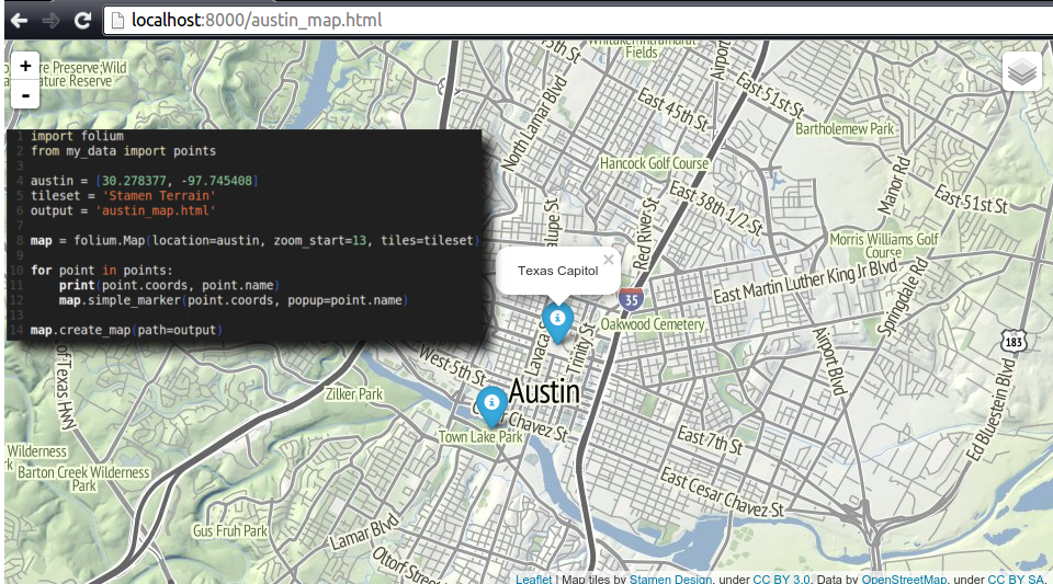
14 lines of Python generates the HTML + JavaScript needed to display existing data on a web map
Building spatial-ized web applications
Web apps are interactive: taking input, storing data, producing output
Geodjango: create web apps that incorporate spatial data
GeoDjango lets you use a spatial database (e.g., PostGIS) to power a spatial-ized app: run spatial queries, return geometries, build maps
Making life better
Easy ways to start using Python as a GIS person
Get Fancy with the Field Calculator
Use Python to generate calculated field values:
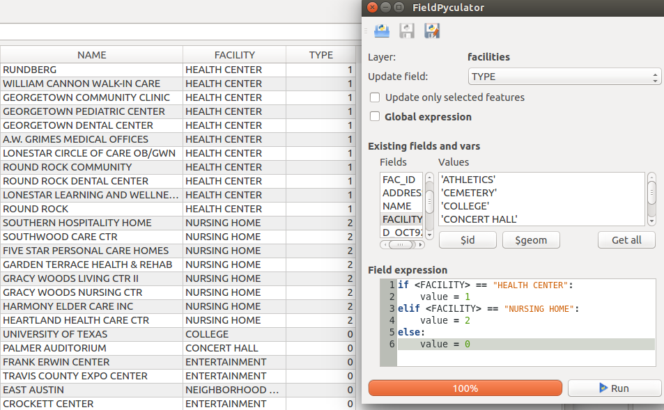
Do it in QGIS with the FieldPyculator plugin
Check your work
Humans make mistakes: use Python to make QA/QC tools
- Programmatically verify schemas & data consistency
- Check for geometry issues (gaps, overlaps, slivers, etc)
- Clean messy field values (mixed caps/lowercase, spaces vs. underscores, etc)
Automation!
Let Python do repetitive tasks for you.
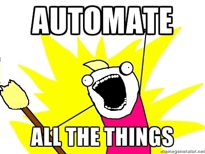
Life is too short to manually reproject 50 shapefiles,
then convert them all to GeoJSON...
TL;DR:
Python makes a lot of things a lot easier
You don't have to be a programmer to take advantage
Easy to get started, endless possibilities!